Most visitors to the Central Pacific coast of Costa Rica follow a predictable script: arrive in Jacó, hit the beach, maybe squeeze in a zip-line tour, then move on. It’s a perfectly fine trip — but it’s also a fraction of what this region actually offers. The Central Pacific is one of the most ecologically concentrated corridors in the entire country, a transition zone where Pacific dry forests meet humid rainforest, where rivers carve through volcanic rock, and where wildlife density rivals even the more famous destinations to the south. The problem isn’t that the hidden gems don’t exist — it’s that most people never look past the hotel pool to find them.
This guide is built for the traveler who suspects there’s more. Whether you’re staying in Jacó for a week or passing through on a tight itinerary, the Central Pacific rewards curiosity with experiences that most tourists — even repeat visitors — never encounter. From forgotten waterfall trails to wildlife corridors that most tour operators overlook entirely, what follows is a deep, practical exploration of the region’s best-kept natural secrets in 2026.
Why the Central Pacific Is More Than Just Jacó Beach
The Central Pacific’s reputation as a party beach destination has long overshadowed its ecological identity. In reality, this stretch of coastline — running roughly from Tárcoles in the north to Dominical in the south — sits at the intersection of some of Costa Rica’s most important biodiversity corridors. The region deserves to be understood on those terms first.
Jacó itself sits within the Garabito canton of Puntarenas Province, a relatively compact administrative area that nonetheless contains an extraordinary range of habitats: estuaries, mangroves, primary and secondary rainforest, river gorges, coastal cliffs, and agricultural buffer zones. The Carara National Park — located just 23 kilometers north of Jacó — marks one of the world’s most significant transition zones between Mesoamerican dry forest and lowland Pacific rainforest. Within that park, and in the forests that connect it to the communities around Jacó, you’ll find scarlet macaws, crocodiles, capuchin monkeys, and hundreds of bird species sharing space in a way that’s genuinely rare on a global scale.
Further south, the coastline from Herradura to Esterillos offers a completely different character: quieter beaches, small fishing communities, and mangrove estuaries that see almost no structured tourism despite being home to remarkable wildlife. The Río Tárcoles estuary — famous for the crocodile-watching bridge on the Costanera highway — is just the entry point to a river system that extends deep into the hills behind the coast, feeding waterfalls and forest pools that most visitors never connect to the river they spotted from a car window.
Understanding the Central Pacific as an ecological system rather than a resort zone is what changes how you travel here. Once you see the geography for what it is — a living corridor connecting marine, riverine, and forest environments — you start to notice opportunities that don’t appear in any standard travel itinerary. This is the lens through which every recommendation in this article is written.
The Infrastructure Advantage Most Travelers Miss
One practical reality that makes the Central Pacific ideal for off-the-beaten-path exploration is its infrastructure. Unlike the Osa Peninsula — which offers comparable wildness but requires significant logistical effort to reach — the Central Pacific is easily accessible from San José (roughly 1.5 hours via the Costanera highway), yet feels dramatically removed from urban Costa Rica once you step off the main road. This means you can base yourself in Jacó, enjoy convenient amenities, and still access genuinely remote natural experiences within 30–60 minutes of driving.
For travelers on limited time — particularly cruise passengers docking at Caldera, just 20 kilometers north of Jacó — this accessibility is a genuine asset. A half-day in the Central Pacific, guided properly, can deliver wildlife encounters and waterfall experiences that rival multi-day itineraries elsewhere in the country.
Hidden Waterfalls of the Central Pacific Interior: The Ones Nobody Talks About
The Central Pacific’s waterfalls are among its most underappreciated assets. While the entire country celebrates destinations like La Fortuna’s Catarata del Río Cuarto or the falls near Monteverde, the river systems behind Jacó and Quepos host waterfalls that are often more dramatic, more accessible, and entirely uncrowded. The reason they’re overlooked is simple: they don’t have paved access roads or ticket booths, and finding them requires either local knowledge or a guide who genuinely knows the terrain.
Catarata Bijagual: The Tallest Waterfall in the Region
Catarata Bijagual is arguably the Central Pacific’s most spectacular hidden waterfall, yet it remains almost entirely off the international tourism radar. Located in the mountains above Jacó, near the small community of La Cima, this waterfall drops approximately 180 meters in a series of cascades through dense primary forest — making it one of the tallest accessible waterfalls in Puntarenas Province. The access trail involves a genuine hike through working farm land and forest, crossing streams and climbing through terrain that rewards physical effort with total solitude.
What makes Bijagual extraordinary isn’t just its scale. The waterfall sits within a private nature reserve that has been managed by the same local family for decades — an example of the kind of grassroots conservation that Costa Rica’s Ley de Biodiversidad and PSA (Pagos por Servicios Ambientales) program have quietly enabled across the country’s rural communities. Visiting with a knowledgeable local guide means your entrance fee goes directly to the family maintaining this land, a concrete example of ecotourism working exactly as intended.
The surrounding forest is exceptional for wildlife observation, particularly in the early morning. Spectacled owls, trogons, and the occasional puma have been documented in this corridor. The trail itself varies in difficulty depending on season — during the invierno (rainy season, May–November), the streams run high and the forest is spectacularly lush but the trail is significantly more demanding. During the verano (dry season, December–April), the waterfall volume decreases slightly but conditions are more forgiving for hikers.
Río Tárcoles Upper Tributaries: Waterfall Pools in the Shadow of Carara
The upper tributaries of the Río Tárcoles system — the same river that draws crocodile-watchers to the highway bridge — carve through the hills behind Carara National Park in ways that most visitors never explore. Several of these tributaries pass through private farm and forest land that can be accessed with local permission and a guide, revealing swimming holes, tiered cascades, and forest corridors that feel genuinely prehistoric in their density.
These sites don’t have formal names on maps. They’re known by the families who farm the surrounding land, by the guides who grew up in the communities of Bijagual, Quebrada Ganado, and Tárcoles itself. This is exactly the kind of local knowledge that separates a transformative experience from a standard tour — and it’s the kind of knowledge that a Jacó-based operator with deep community roots can actually provide.
Naranjo River Cascades Near Quepos
Forty-five kilometers south of Jacó, the area around Quepos and Manuel Antonio is far better known — but even here, the interior river systems remain largely unexplored by visitors who stick to the national park’s main trail. The Río Naranjo and its tributaries in the hills above Quepos pass through secondary forest and old palm plantation land that has been reverting to natural vegetation for decades. The result is a mosaic of habitats that’s visually dramatic and ecologically rich, punctuated by small waterfalls and deep green swimming pools that see almost no visitor traffic.
Reaching these sites typically requires a combination of driving on unpaved roads and short hikes across private land — the kind of access that’s only possible with a local operator who has established relationships with landowners. For travelers willing to venture 30 minutes inland from the coastal tourist corridor, the contrast with the crowded Manuel Antonio National Park entrance is almost surreal.
Wildlife Corridors and Secret Trails: Where the Animals Actually Are
Costa Rica’s reputation for wildlife is deserved, but the way most tourists experience that wildlife — standing on a marked trail in a national park with thirty other visitors — doesn’t do justice to what’s actually possible. The Central Pacific has several wildlife corridors and secondary forest areas that offer genuinely intimate encounters with the country’s iconic species, largely because they’re not on standard tour routes.
The Carara Buffer Zone: A Birding Paradise Without the Crowds
Carara National Park is justifiably famous among serious birders — it protects the largest scarlet macaw population on the Pacific coast of Costa Rica, and its transitional forest supports over 400 bird species. What most visitors don’t realize is that the park’s buffer zone — the private land surrounding its boundaries — is equally productive for wildlife, and can be accessed through guided tours that visit farms and forest remnants just outside the official park boundary.
Scarlet macaws, for example, don’t restrict themselves to park boundaries. They roost in the forest but forage across a wide area, including agricultural land with large fruiting trees. Early morning guided walks in the buffer zone communities of Tárcoles and Quebrada Ganado can produce macaw encounters at close range, along with capuchin monkeys, coatis, iguanas, and a remarkable diversity of raptors. The SINAC (Sistema Nacional de Áreas de Conservación) manages the park itself, but the surrounding communities are the ones who make the broader corridor functional — and visiting those communities directly supports that conservation work.
For bird photographers in particular, the buffer zone offers something the park interior rarely provides: subjects at eye level, in open light, without crowds of other visitors creating disturbance. A dawn departure from Jacó puts you in the field well before the tour buses arrive, in conditions that are simply incomparable for photography and observation.
Mangrove Estuaries: The Overlooked Ecosystems of the Coast
The Central Pacific coast has several mangrove estuaries that receive almost no tourism attention despite being spectacular wildlife habitats. The estuary at Herradura Bay, just north of Jacó, supports a healthy population of American crocodiles, various heron species, boat-billed herons, and black-crowned night herons, as well as the occasional white ibis and roseate spoonbill during migration periods. Small boat excursions through this estuary — possible only with a guide who knows the channels — provide wildlife encounters that rival anything available at more famous wetland destinations.
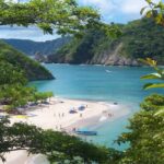
Further south, the Damas Estuary near Quepos is one of the Central Pacific’s genuine crown jewels for wildlife observation. Covering several hundred hectares of mangrove forest threaded with navigable channels, the Damas system supports three species of Costa Rican monkeys (white-faced capuchin, mantled howler, and the endangered Geoffroy’s spider monkey), along with caiman, crocodiles, river otters, and an extraordinary diversity of water birds. Kayak tours through the narrower channels provide an experience of genuine immersion — paddling through cathedral-like corridors of mangrove root, with monkeys moving overhead and water birds flushing from the vegetation ahead of you.
The key insight about the Damas Estuary is timing. Most day-trippers arrive mid-morning when wildlife activity has already peaked. Dawn departures from Jacó — which put you on the water at first light — produce encounters with species that are simply inactive by 9:00 AM. This is the kind of practical local knowledge that makes the difference between a decent wildlife tour and an extraordinary one.
The Wildlife Corridors of Fila Chonta and Fila Costeña
Running parallel to the coast, the low mountain ranges of Fila Chonta and, further south, Fila Costeña serve as critical wildlife corridors connecting the larger protected areas of the Central Pacific to the Osa Peninsula beyond. These ranges are largely covered in private forest reserves and small-scale farms, and they see virtually no organized tourism despite being rich in wildlife and topographically dramatic.
Within these hills, rivers drop off escarpments in waterfalls that feed the lowland river systems, creating habitats for amphibians, reptiles, and forest birds that are rarely seen at coastal elevations. Guided hikes into these corridors — typically departing from communities like Parrita, Savegre, or the farming communities above Quepos — offer the kind of total solitude in nature that’s becoming genuinely rare in Costa Rica as tourist infrastructure expands.
The Cultural Landscape: Communities the Tourist Trail Ignores
Authentic travel isn’t only about wildlife and waterfalls. The Central Pacific has a human geography that’s equally fascinating and almost entirely overlooked by conventional tourism. Understanding who lives in this landscape, and how they interact with it, adds a dimension to the experience that no amount of wildlife watching can replicate on its own.
Fishing Villages and the Coast Between Jacó and Quepos
The Costanera highway between Jacó and Quepos passes through a series of small coastal communities — Esterillos Oeste, Esterillos Centro, Esterillos Este, Boca Damas, and Savegre — that most visitors experience only as a blur from a car window. These communities have been shaped by fishing, small-scale agriculture, and increasingly by ecotourism, and they offer a version of Costa Rican coastal life that’s completely different from the resort town atmosphere of Jacó or the national park tourism of Manuel Antonio.
Local fishing families in these communities often maintain small boats and knowledge of the coastline that’s genuinely exceptional. Informal fishing tours — arranged through community contacts rather than hotel desks — can include pre-dawn departures to watch the sunrise over the Pacific while handlining for local species, followed by a breakfast of fresh catch prepared on the beach. This isn’t a formalized tourism product. It’s an experience that exists because local families are willing to share their working lives with curious visitors who approach with genuine respect.
Pineapple and Palm Communities: Agriculture as Landscape
The agricultural interior of the Central Pacific — particularly the broad flatlands between Parrita and Quepos — is dominated by palm oil and pineapple cultivation, two industries that have profoundly shaped this landscape over the past several decades. This is a complicated story: both industries have been criticized for environmental impact, but both also employ tens of thousands of Costa Rican families in a region where alternatives are limited.
Responsible tour operators in the region engage with this complexity honestly, offering visitors a nuanced understanding of how agricultural and conservation land use interact in the Central Pacific. Walking through a community adjacent to palm cultivation and then into a river corridor that’s been protected by the same community reveals the tensions and the possibilities of land stewardship in a developing economy — a far more intellectually honest experience than the sanitized “pure nature” narrative that most tourism products present.
Practical Guide to Exploring Off the Beaten Path: What You Need to Know
Venturing beyond the standard tourist trail in the Central Pacific requires preparation, local knowledge, and a realistic understanding of conditions. This section covers the practical dimensions that make the difference between an adventure and a misadventure.
When to Go: Timing Your Off-the-Beaten-Path Experience
The dry season (December through April) is the obvious choice for most visitors — roads are passable, trails are manageable, and the weather is predictably sunny. But for experienced travelers and those interested in the most dramatic waterfall experiences, the rainy season tells a different story. From May through November, the Central Pacific’s rivers run full, waterfalls reach their peak volume, and the forest is at its most lush and alive. Wildlife activity is generally higher in the early rainy season (May–July) before the heaviest rainfall periods of September and October.
The practical compromise for most visitors is the transitional months of May, June, and November — technically within the rainy season but with more moderate and predictable precipitation. During these months, you can typically count on clear mornings for hiking and wildlife observation, with afternoon rain that cools the landscape and fills the waterfalls. Experienced operators know this rhythm well and can structure itineraries that work with, rather than against, the seasonal pattern.
Physical Preparation: What Off-the-Beaten-Path Actually Means Here
It’s important to be honest about what “off the beaten path” involves physically in the Central Pacific. Most of the hidden waterfall trails described in this article involve uneven terrain, stream crossings, and significant elevation gain over short distances. The combination of humidity, heat (typically 28–34°C at lower elevations), and trail difficulty means that fitness preparation matters, and that visiting with a guide who can assess your capabilities and adjust the experience accordingly is genuinely important rather than just a commercial convenience.
That said, many of the region’s less-visited sites are entirely accessible to reasonably fit adults without specific athletic training. The key variables are hydration, appropriate footwear (closed-toe shoes with grip, not sandals), sun protection, and a realistic pacing strategy. A good guide will always manage pace and conditions; a visitor who communicates their fitness level honestly will have a far better experience than one who overstates their capabilities.
Working with Local Guides: Why It’s Non-Negotiable Here
The Central Pacific’s off-the-beaten-path experiences are, almost without exception, inaccessible without local guide knowledge. This isn’t marketing language — it’s a practical reality. The hidden waterfall trails in the hills above Jacó cross private land where permission depends on relationships that local operators have built over years. The wildlife corridors worth visiting require knowing where to position yourself at what time of day in what season. The mangrove channels that hold the best wildlife are not on maps and are not navigable by anyone unfamiliar with the tidal patterns of the specific estuary.
Working with a licensed, experienced local operator isn’t just about safety — though that’s critical — it’s about access. The experiences described in this article exist because local guides have invested years in building the community relationships and ecological knowledge that make them possible. The Instituto Costarricense de Turismo (ICT) maintains licensing standards for tour operators, and choosing a licensed operator is the first quality filter to apply when planning any off-the-beaten-path excursion in Costa Rica.
Understanding Environmental Responsibility in Practice
Costa Rica’s ecotourism framework is built on a genuine regulatory and cultural foundation. The Certificación para la Sostenibilidad Turística (CST) — administered by the ICT — provides a credible benchmark for tourism operators who are genuinely committed to environmental and community standards, not just using “eco” as a marketing label. When selecting a tour operator for off-the-beaten-path experiences, asking about their CST certification level (rated 1–5 leaves) is a practical way to assess their actual sustainability practices.
Beyond certification, responsible off-the-beaten-path travel in the Central Pacific means following Leave No Trace principles with particular rigor — taking nothing from natural sites, staying on trail in sensitive habitats, not disturbing nesting wildlife, and respecting private land boundaries. In a region where conservation depends heavily on the goodwill of private landowners, visitor behavior directly affects whether these access points remain open to future travelers.
The SINAC national conservation areas system provides important context for understanding which areas are formally protected and which are accessible through community and private land arrangements — a distinction that matters for understanding the rules that apply in different settings.
The Photography Angle: Why the Central Pacific’s Hidden Sites Are Exceptional
For travel photographers, the Central Pacific’s lesser-known sites offer something that the famous destinations increasingly cannot: intimacy. Photographing scarlet macaws at dawn in a buffer zone community, without other tourists competing for position, produces images that are qualitatively different from the same species photographed from a crowded park trail. The same is true for waterfall photography — the ability to approach a cascade from multiple angles, to set up a long exposure without interruption, to wait for the light to shift without a queue of people behind you, produces work that simply isn’t possible at heavily visited sites.
Waterfall Photography: The Technical and the Practical
The Central Pacific’s waterfalls present specific photographic challenges and opportunities. The combination of forest canopy and mist creates lighting conditions that are beautiful but technically demanding — contrast between the bright water and the shadowed forest requires careful exposure management, and the constant moisture in the air demands weather-sealed equipment or at minimum a rain cover for camera bodies and lenses.
Early morning light is almost always preferable for waterfall photography in the Central Pacific — the soft, directional light of the first hour after sunrise penetrates forest canopy at angles that aren’t available later in the day, and the relative stillness of early morning reduces the mist disturbance that midday heat creates. Most serious photographers visiting the region’s hidden waterfalls depart before 5:30 AM — which, from Jacó, is entirely practical given the proximity of many sites.
Long exposure techniques (typically requiring a tripod and neutral density filters) transform moving water into the silky, flowing forms that characterize the best waterfall photography. At sites with no visitor traffic, setting up a tripod and taking the time to compose properly is entirely feasible — a luxury that’s simply not available at crowded commercial waterfall sites where constant movement in the frame makes long exposures impossible.
Wildlife Photography in the Buffer Zone and Mangroves
Wildlife photography in the Central Pacific’s off-the-beaten-path locations rewards patience and preparation in ways that standard wildlife tours don’t. In the Carara buffer zone, scarlet macaws can be observed at close range from fixed positions near known roosting trees — a situation that allows genuine preparation of composition, focus, and exposure settings before the subjects arrive, rather than the frantic reaction photography that most wildlife encounters require.
Mangrove kayak tours through the Damas Estuary offer wildlife photography conditions that are exceptional by any standard. The low-angle, eye-level perspective from a kayak, the ability to approach subjects quietly without engine noise, and the extraordinary diversity of subjects available in a single paddle make the Damas one of the most productive wildlife photography environments on the Pacific coast of Costa Rica.
How to Plan a Multi-Day Off-the-Beaten-Path Itinerary from Jacó
Jacó’s position at the northern end of the Central Pacific corridor makes it the ideal base for multi-day exploration of the region’s hidden gems. The following itinerary framework reflects practical travel realities in 2026 — road conditions, seasonal timing, and the geographic distribution of the sites described throughout this article.
Day One: The Northern Zone — Carara and Tárcoles
A dawn departure from Jacó heading north puts you at the Tárcoles estuary and Carara buffer zone in time for the morning wildlife peak. The crocodile-watching bridge on the Costanera is genuinely spectacular — American crocodiles here are among the largest in Costa Rica, and the viewing is extraordinary — but treating this as a brief stop rather than the main event allows time for the more substantive experience of a guided buffer zone walk before the heat of midday sets in.
Return via the back roads through Quebrada Ganado for a late morning coffee at a local soda (family restaurant), then spend the afternoon on the Bijagual waterfall trail if fitness allows, or exploring the Río Tárcoles upper tributaries with a local guide. Return to Jacó by early evening.
Day Two: The Southern Coast — Esterillos and Damas
A second day heading south along the Costanera reveals a completely different character of the Central Pacific. The communities of Esterillos and Boca Damas sit on a coastline that’s quieter and less developed than Jacó’s beach, with a more authentic fishing community atmosphere. A morning spent exploring the Esterillos coast on foot — watching pelicans work the surf, checking the tideline for wildlife — transitions naturally into an afternoon kayak excursion through the Damas Estuary mangroves.
The estuary paddle in afternoon light has its own rewards: herons and egrets are active at the water’s edge, spider monkeys are vocal and visible in the canopy above the mangrove margins, and the low light of late afternoon gives the green corridors of the mangrove forest a luminous quality that’s genuinely beautiful. Return to Jacó via Quepos, with a stop for dinner in the town center.
Day Three: The Interior — Bijagual and Fila Chonta
A day dedicated to the mountain interior above Jacó provides the most dramatic contrast with the coastal experience of the preceding days. The Bijagual waterfall trail is the centerpiece — an experience that requires a full day to do properly, with time to hike in, explore the waterfall and its surroundings, and return at a comfortable pace. Early departure (before 6:00 AM) is strongly recommended, both for the coolest trail conditions and for the wildlife observation opportunities in the forest at dawn.
The return journey can be routed through La Cima and the farming communities above Jacó for a perspective on the Central Pacific’s agricultural interior that complements the forest and coastal experiences of the previous days.
What Makes a Great Guide in the Central Pacific? Questions Worth Asking
Not all guides are equal, and in the Central Pacific’s off-the-beaten-path context, the quality of your guide is the single most important variable in the quality of your experience. Beyond the basic requirement of ICT licensing, several indicators distinguish guides who genuinely know the region from those who are simply leading a standard itinerary.
A guide with genuine expertise will be able to speak to seasonal variation in specific sites — explaining not just whether a waterfall is “good” but how its character changes between dry and rainy season, which access route is better at what time of year, and what wildlife species are present during which months. They will have personal relationships with the landowners and communities whose land the tours access, and they’ll be able to describe those relationships and their conservation significance.
The best local guides are also naturalists in the genuine sense — able to identify bird species by call before they’re visible, to explain the ecological relationships between the species encountered on a trail, and to read the forest for signs of wildlife activity that most visitors would walk past without noticing. This kind of knowledge takes years to develop and can’t be replicated by reading a field guide before a tour.
When evaluating any operator for off-the-beaten-path tours in the Central Pacific, asking specific questions — “Which season is best for the Bijagual trail and why?” or “How do you access private land sites, and what community relationships support that?” — quickly reveals the depth of local knowledge on offer. An operator with genuine expertise will answer these questions with enthusiasm and specificity. An operator reading from a script will not.
Frequently Asked Questions About the Central Pacific’s Hidden Gems
What is the best time of year to visit the Central Pacific’s hidden waterfalls?
The rainy season (May–November) produces the highest waterfall volumes, but trail conditions are more challenging. The transitional months of May, June, and November offer a practical balance of accessible trails and impressive water flow. The dry season (December–April) provides easier hiking but reduced waterfall volume at some sites.
Are the off-the-beaten-path sites in the Central Pacific safe?
When accessed with a licensed local guide, these sites are safe for reasonably fit adults. The risks — slippery trails, stream crossings, wildlife encounters — are all manageable with proper guidance, appropriate footwear, and realistic fitness expectations. Solo exploration of unmarked trails is not recommended in any part of Costa Rica’s forest.
How far are the hidden waterfall sites from Jacó?
Most sites are within 30–60 minutes of Jacó by vehicle. Catarata Bijagual is approximately 20–25 minutes by car plus a hiking approach. The Carara buffer zone is about 20 minutes north. The Damas Estuary is roughly 45 minutes south near Quepos.
Do I need special permits to visit these areas?
Sites within national parks require standard SINAC entrance fees. Private land sites — including some waterfall trails — require permission from landowners, which is typically arranged in advance by local tour operators. A licensed operator handles all necessary permissions as part of the tour arrangement.
Can families with young children visit hidden waterfall sites?
Some sites are suitable for families with children; others require adult fitness levels. A good local operator can recommend appropriate sites based on the ages and fitness levels in your group. The Damas Estuary kayak tour, for example, is accessible to children of school age with appropriate life jackets and adult supervision.
What should I bring for an off-the-beaten-path day trip from Jacó?
Essential items include closed-toe shoes with grip, lightweight long pants, sun protection, insect repellent, a refillable water bottle, and a rain jacket. A dry bag for electronics is highly recommended. Most guided tours provide entrance fees, transport, and a guide — confirm what’s included when booking.
What wildlife can I realistically expect to see in the Central Pacific?
The Central Pacific is one of Costa Rica’s most productive regions for wildlife observation. Scarlet macaws, multiple monkey species, crocodiles, caimans, iguanas, and a remarkable diversity of water birds are commonly encountered on well-guided excursions. Big cats (pumas, ocelots) are present in the region but rarely observed.
How does the CST certification affect my choice of tour operator?
The CST (Certificación para la Sostenibilidad Turística) provides an independently verified measure of an operator’s environmental and community practices. A higher CST rating (more leaves) indicates more rigorous sustainable practices. It’s a useful but not exclusive quality indicator — some excellent small operators have not completed the certification process but maintain high standards in practice.
Is the Damas Estuary really worth visiting if I’ve already been to Tortuguero?
Yes — the Damas Estuary offers a different ecological character and a more intimate experience than Tortuguero’s larger, boat-based tours. The ability to paddle through narrow mangrove channels by kayak, with no engine noise and at eye level with wildlife, is qualitatively different from the motorized boat tours at Tortuguero, though the scale is smaller.
What’s the difference between visiting Carara National Park and the buffer zone?
Carara National Park offers marked, maintained trails with formal infrastructure and SINAC ranger presence. The buffer zone offers unstructured, guide-led access to private land adjacent to the park, with fewer visitors, more flexible routing, and often superior wildlife photography conditions — but requires a local operator with established community access.
Can I visit hidden waterfall sites during a cruise port stop at Caldera?
Yes — Caldera port is approximately 20 minutes from Jacó, making the Central Pacific’s hidden gems genuinely accessible for shore excursions. A half-day guided tour can include a waterfall hike or wildlife experience with comfortable time margins for return to the port. Pre-booking with a licensed local operator is essential for cruise excursions.
How do I know if a tour operator genuinely knows the off-the-beaten-path sites versus following a standard script?
Ask specific, seasonal questions. An operator with genuine expertise will answer questions about seasonal variation, access conditions, and wildlife specifics with confidence and detail. Reading verified reviews that specifically mention naturalist knowledge and trail conditions is also a reliable indicator of genuine local expertise.
Making the Most of the Central Pacific: A Final Perspective
The Central Pacific of Costa Rica in 2026 is at an interesting crossroads. Its main destinations — Jacó, Manuel Antonio, the Carara bridge — are more visited than ever, and the infrastructure supporting tourism has expanded significantly. At the same time, the hidden layers of this region remain remarkably intact: the waterfalls above Jacó are no more crowded than they were a decade ago, the mangrove estuaries are as wild as ever, and the communities that maintain access to private forest land are still there, still welcoming visitors who approach with genuine curiosity and respect.
What this means practically is that the window for the kind of experience described in this article is not closing — but it does require intentionality. The Central Pacific will give you exactly what you seek. If you stay on the main roads and visit the obvious sites, you’ll have a pleasant trip. If you invest in local knowledge, wake up before dawn, and trust a guide who genuinely knows this landscape, you’ll have something else entirely: an experience of one of the world’s most biodiverse regions at a depth that most visitors never access.
The Área de Conservación Pacífico Central (ACOPAC) — the SINAC conservation area that encompasses most of what’s described in this article — manages one of Costa Rica’s most complex and productive coastal-forest mosaics. Understanding that you’re traveling within a formally protected landscape, supported by decades of conservation investment and community stewardship, gives context to every experience this region offers.
The Central Pacific’s hidden gems aren’t hidden because they’re difficult to find. They’re hidden because finding them requires the right questions, the right guide, and the willingness to look beyond what’s immediately obvious. That willingness is, ultimately, what defines the difference between a tourist and a traveler — and the Central Pacific rewards travelers generously.